Yamaha Motor Industrial-Use Unmanned Helicopters: Forestry Survey
October 28, 2019
IWATA, October 28, 2019 -Yamaha Motor Co., Ltd. (Tokyo: 7272) announced today that the company in a consortium with woodinfo, Inc., Remote Sensing Technology Center of Japan, and Maruyoshi Limited, will collect data on “Increased Wood Material Production AI Construction Model Projects'' in Kumakougen Town, commissioned by Ehime Prefecture for 3 days from October 28.
This project will utilize industrial-use unmanned helicopters to measure the topography as well as tree density, alignment, numbers, and trunk diameters. Using the systems available through the consortium to capture this information as digital data, it aims to contribute to the development of appropriate and efficient forestry management plans and the creation of forestry asset value.
Under the Forestry Management Act which took effect in April 2019, forestry management is now mandatory for forest owners. However, current issues include a lack of the labor force necessary to maintain forests in an appropriate state, and owners not obtaining the quantitative data required for asset value improvement.
To date, Yamaha Motor has continuously provided valuable aerial-based solutions utilizing unmanned helicopters such as 1) its agricultural chemical sprayer business (principally for rice paddies) - in which it has over 30 years' experience, 2) observation of disaster sites such as volcanic eruptions and landslides, and 3) transport of maintenance materials for electricity transmission towers in mountainous areas. By conducting high-efficiency forestry measurement from above utilizing the advanced performance of unmanned helicopters such as extended flight time, this trial aims to contribute to improved productivity in forestry management.
Through the development and application of unmanned vehicle and robotics technology, Yamaha Motor will continue to provide value in the form of labor saving, automation, and productivity improvements, while also helping to address social issues in the unique style of Yamaha.
Plan Overview
| Dates | : | October 28-30, 2019 (Mon.-Wed.) |
| Location | : | 4 forests in Kumakogen, Ehime Prefecture (approx. 20-25 ha) |
| Trial Name | : | Forestry Surveying utilizing Laser Scanning Systems Mounted on Unmanned Helicopters |
| Aircraft used for Measurement | : | Yamaha Motor Unmanned Helicopter FAZER R G2 Industrial-Use |
| Measurement Method | : | LiDAR |
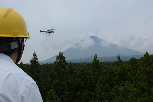
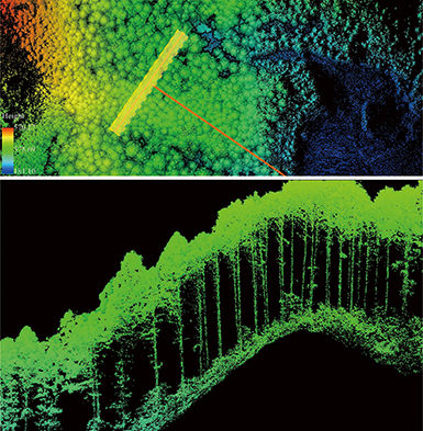
Image of measurement using unmanned helicopters (left) and measurement results (right)