At the request of the Tokyo Metropolitan Government office, Yamaha Motor Co., Ltd. (YMC) deployed a Yamaha "RMAX" industrial-use unmanned helicopter equipped with an observation-use video camera for the purpose of observing the damage from the recent volcanic activity on Miyake-jima island. The helicopter was then used for a series of observation flights of three gorges in the vicinity of the volcano from Feb. 12 to 15. |
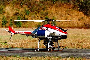
The helicopter used in these observation flights is an "Autonomous-control Spec" modification of the "RMAX " industrial-use remote control helicopter Yamaha developed and markets for agricultural use. To the standard "RMAX" are mounted GPS (Geographic Positioning System) equipment, attitude-control equipment, a communications modem and other instruments necessary to make it capable of fully autonomous flight from take-off and flight navigation to observation over the site, return trip and landing all based on signals programmed on a computer at the base camp. It has a flight range of two kilometers and a continuous autonomous-flight time capability of one and a half hours.
Under the directions of the Tokyo Disaster Prevention Division and the Public Works Department of the Miyake-jima branch of General Affairs Bureau of the Tokyo Government office, an operations team from YMC's Aeronautic Operations joined with the Public Works Research Institute of the Ministry of Land, Infrastructure and Transport and the Bureau of the Construction to land on the now evacuated Miyake-jima island from the nearby Kozu-shima island and set up base camps in the Izu, Kamitsuki and Tsubota districts of the island. From there, flights were made about 1.5 km up the volcano to observe the upper ends of the Botasawa, Kawadasawa and Hotokezawa gorges, taking footage with the digital video camera mounted on the helicopter.
This observation project marks the second time that a Yamaha "GPS Autonomous-flight Unmanned Helicopter" has been used, following the world's first such autonomous observation fights out of the range of sight by a Yamaha helicopter last April at the site of the erupting Mt. Usu in Hokkaido. These efforts have opened up a new realm of possibilities for these unmanned helicopters which until now were used primarily in commercial agriculture. Now a wide range of inspection and observation uses can be anticipated in the fields of environmental and land/resource preservation.
Miyake-jima island
Following the volcanic activity alert last June 26 and the ensuing eruption of Mt. Oyama on July 8, volcanic activity continued intermittently, resulting in the complete evacuation from the island of all its inhabitants on Sept. 2 of last year. Since then, the volcanic activity including the release of volcanic gases has continued, limiting access to the island even by disaster prevention specialists.
The use of the unmanned helicopter under these conditions has enabled the gathering of previously unavailable data such as low-flight observation images from the high-danger areas near the volcano that only a helicopter could provide. This valuable data will now contribute to the research and studies of the various related agencies and research institutions. |