An Unmanned Helicopter that Helped Unravel the Mystery of Continent Formation
介绍雅马哈发动机技术背后的故事。
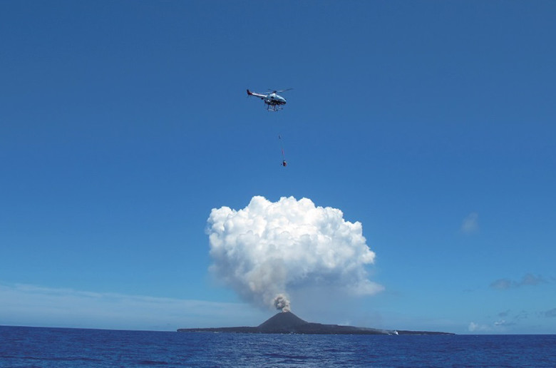
西之岛位于东京以南 1,000 公里的太平洋上。它在 2013 年 11 月中断了 39 年后喷发,熔岩流入海洋逐渐扩大了其陆地面积。科学家们将其视为地球上陆地如何形成的微型模型。日本国家电视台NHK要求雅马哈发动机公司协助获取该地区的特写镜头拍摄纪录片,*因此我们合作提供了一架特制的RMAX G1工业用无人直升机(以下简称“无人直升机”)完成任务. 2015 年夏天,该飞船拍摄了该地区的视频片段,并协助获取了火山岩样本。
虽然雅马哈的无人直升机最初是为了帮助提高日本的粮食自给率而设计的,但如今它们通过为摄影和测量等农业以外的领域提供解决方案而发挥了更大的作用。这些工作包括测量地震活动、记录火山周围的磁场、进行地形调查、测量辐射和观察潮地。 RMAX G1 在西之岛的工作再次证明了无人直升机的广泛使用可能性。
*“土地的起源-西之岛,解开大陆是如何形成的奥秘”于2015年8月在NHK播出
Designing the RMAX with an Eye on the Future
Boosting Japan’s ability to produce enough food to sustain itself has long been a prominent national issue. There were and still are many aspects to be addressed: the amount of arable land in Japan is small as well as scarce, the average age of farmers continues to rise, there is a lack of those willing to inherit family-run farms and the demographics and structure of farming communities is changing. Pest insects reproduce for two to three generations as they make their homes in rice fields from spring and fall. Birds also flock to the rice paddies. So, in light of such issues, our industrial-use unmanned helicopters, which make conducting crop dusting more efficient, provided an answer to some of these needs.
Yamaha unveiled the R-50 in 1987 as its first industrial-use unmanned helicopter. It was the world’s first unmanned helicopter capable of carrying and spreading a 20 kg payload of agrichemicals, and it was not long before the R-50 was at work spraying rice paddies from the air. Data was collected during the model’s initial usage monitoring period, and the R-50 (#1) was officially made available for sale in 1989.
Its successor, the RMAX, was released in 1997. It featured 10 on-board CPUs that constantly monitored its status mid-flight, and made it possible to control the craft should an electronics error occur mid-flight. In addition to its crop dusting capabilities, the RMAX was designed to be adaptable for other uses that the engineers expected it would see in the future. They had an eye on one day developing an unmanned helicopter capable of fully automatic flight; the helicopter would automatically take off, fly a pre-determined flight path, and then return to its starting point and land—all with the touch of a single button. But in the late 1990s, the RMAX’s growth in the agricultural sector had subsided, so while the technology itself had already been proven by an advanced development team, practicalization with a final product was postponed.
The RMAX G1 Begins Observation and Measurement Work
In March 2000, on Japan’s northern island of Hokkaido resumed volcanic activity after a being relatively dormant for some time. The area surrounding the volcano was declared off-limits, and as authorities rushed to gather information on the volcanic activity, the Ministry of Construction (name at the time) made a request to Yamaha for an unmanned helicopter to observe the area near the mouth of the volcano, and a team was quickly assembled. After two weeks of working round-the-clock, a system was developed to allow the helicopter to fly automatically through areas beyond the range of human vision. This was the birth of the special automatic-flight-equipped RMAX (#2) for observing Mt. Usu. In addition to the sensor for the Yamaha Attitude Control System (YACS) that came standard on the model, this RMAX version included a directional sensor and GPS, which allowed it to detect its position, speed and more. Furthermore, the team created and implemented a Real-Time Kinematic Differential GPS (RTK-DGPS) system to allow the helicopter to fly with even more precision.
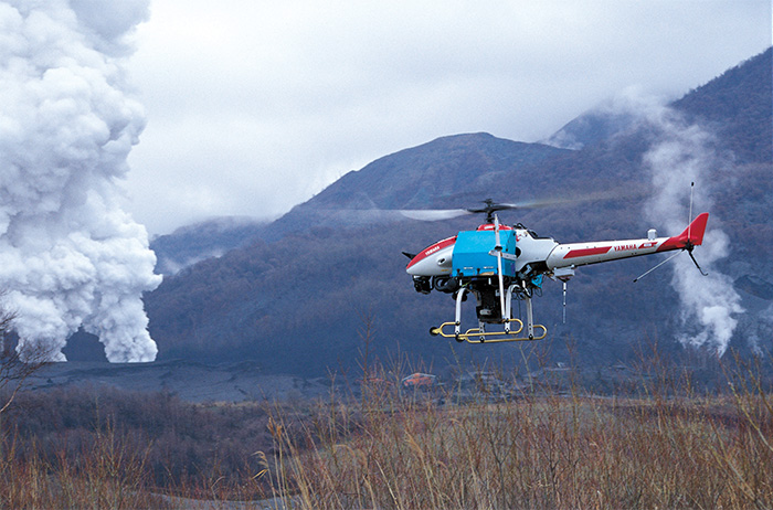
After successful test flights along the coast of Enshunada in Shizuoka Prefecture, the RMAX was taken to Mt. Usu at the end of April. Its job was to provide support for manned observation helicopters, which it accomplished by flying near and photographing the volcano’s vents. It was the first time in the world for an unmanned helicopter to automatically fly beyond the range of human vision based on a pre-programmed flight path. Information about topographic changes and the status of volcanic ash plumes were sent in clear, real-time video to the observation headquarters. This not only provided the indicators and details needed for making weather forecasts but also demonstrated the advantages of unmanned helicopters at the same time.
To create such a flight system in just a few weeks after receiving the request was thanks to the basic research into automatic flight that Yamaha was conducting at the time. This achievement at Mt. Usu also had the added effect of speeding up the development of the next generation of the RMAX.
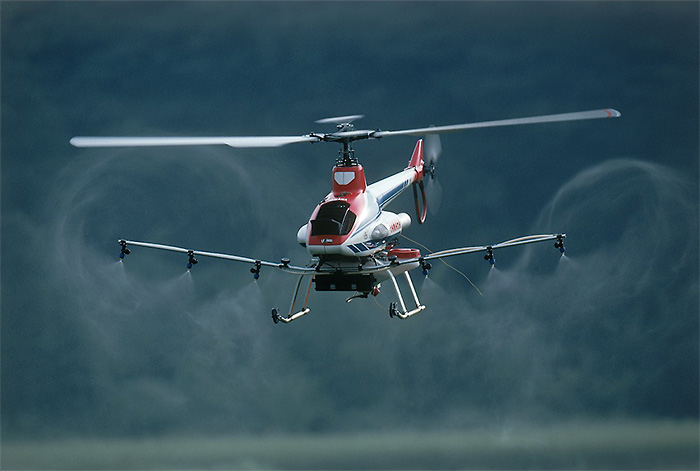
Launched in 2003, the RMAX Type II G (#3) featured a high-precision GPS for agricultural use, and later in 2006, a model based on the Type II G but with added automatic flight capabilities, the RMAX G1 (#4), was released.
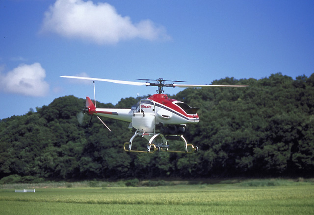

The RMAX G1’s YACS and RTK-DGPS systems allowed it to fly along pre-programmed flight paths. It could fly well beyond visible distances while accurately controlling its own position, operators could verify its airspeed via GPS and the craft could maintain a set airspeed. It could be outfitted with cameras and monitoring equipment specific for each application to acquire information in real time. The RMAX G1 is utilized today in a variety of fields, such as volcano surveys and seismic data collection.
The RMAX G1 Shows Its Potential at Nishinoshima
There were new challenges for the RMAX G1’s imagery and observation duties at Nishinoshima, such as attitude control, providing a location for takeoff and landing and signal interference.
The craft needs to sense its pitch angle (angle in relation to the ground) in order to control itself in flight. Using a gyro sensor to measure angular velocity and performing time-integrated calculations based on that alone would lead to a buildup of calculation errors, so a separate accelerometer and directional sensor were added to function in tandem and ensure calculation accuracy. However, each time the helicopter is switched on and the gyro sensor starts up, an offset is generated within the data it provides, so the RMAX G1 is designed to account for this when it is at rest. Still, being “at rest” on a swaying boat deck was too different of an environment from normal, which presented a real challenge.
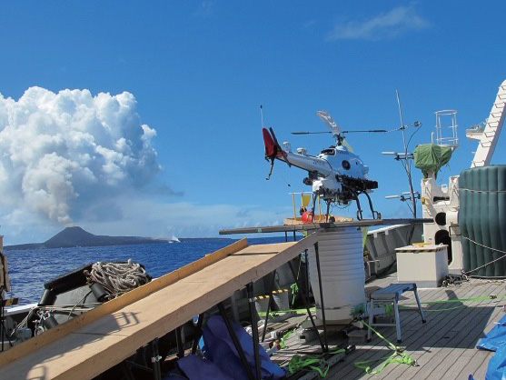
The RMAX G1 needed to takeoff from a ship in the Pacific Ocean about four kilometers away from the volcano’s crater. A small ship’s swaying deck meant that the helicopter couldn’t actually be motionless, meaning the gyro sensor would provide inaccurate data when activated. To overcome this, a bias estimation system using an extended Kalman filter (a calculation algorithm for making estimates) was devised.
The RMAX G1 takes off and lands the same way that the agricultural version does with a pilot operating it via remote control. But doing that in the swaying environment of a ship deck presents a high degree of difficulty, and to carry out precise takeoffs and landings, a level surface is essential. So, a platform was designed (#5) that senses the motion of the ship, and controls an electric motor to adjust the platform in the pitch, roll and yaw directions to cancel out the ship’s movements and keep the platform level at all times, thus guaranteeing steady takeoffs and landings.
The Yamaha team also needed to come up with a solution for “multipath interference,” a phenomenon when radio waves travel from one source to a receiver via more than one path, causing signal interference. This occurred because the radio waves transmitted from the ship tended to bounce off the water surface, causing the signal to fade before it reached the helicopter. The RMAX G1 was designed to automatically return to base if it lost radio reception due to some unknown factor, but should this occur, operation of the onboard camera and sample collection equipment cannot performed. The solution to this was to set up two antennas of varying height on the ship and switch between the two as needed for the flight path.
Yamaha’s unmanned helicopters are seeing use in an ever-expanding variety of fields thanks to creating versions suited for each application through innovative combinations with the latest technologies from our other product lines.