
Case Studies : Topographic Survey of the Maya Site of Copán, UNESCO World Heritage Site
High-density LiDAR visualizes the terrain of an ancient Maya city hidden beneath dense forest
Archaeology
In partnership with Komatsu University, Shizuoka University, and the National Autonomous University of Honduras, Yamaha Motor carried out high-density airborne laser scanning over part of the Maya Site of Copán, a UNESCO World Heritage Site in western Honduras. We extracted the fine terrain beneath the forest to produce baseline information to help identify priority areas for future archaeological surveys.
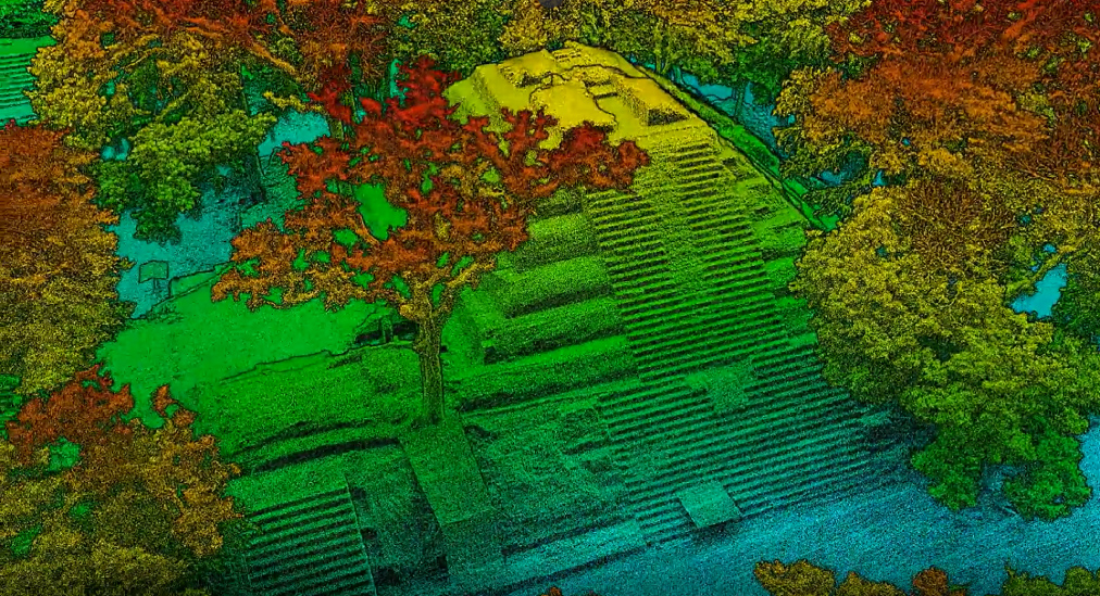
Terrain and vegetation visualized from high-density 3D point cloud data
Copán is one of the principal city sites of the ancient Maya civilization, inscribed on the UNESCO World Heritage List in 1980. Forest surrounds the core of the site, and unidentified landforms and potential archaeological features may remain beneath the canopy and understory vegetation. In this project we recorded terrain and forest structure simultaneously, without substantially disturbing the forest, producing baseline information for field verification by researchers and for future wide-area surveys.
The requirement was not simply to make the ground beneath the forest visible. It was to capture the fine undulations that earlier surveys could not adequately detect, and to acquire ground points at a density that would allow their spatial relationship with known excavated features to be compared. Because the cultural landscape had to be preserved as it stood before excavation and vegetation change, forest structure—canopy, stems, and understory vegetation—needed to be recorded within the same 3D dataset as the terrain.
INDEX
- Background & ChallengeNarrowing down which microtopography to investigate in dense forest
- Yamaha Motor's ApproachA small-scale pilot survey to verify the point density and analytical potential needed for wide-area deployment
- ResultsMicrotopography beneath the forest, visualized at roughly 32 times the ground point density of the earlier survey
- Conclusion
Background & Challenge
Identifying microtopographic features for investigation in dense forest
Inside the forest, visibility is limited, and mound-like undulations are difficult to identify continuously from the ground. Field surveys are indispensable for archaeological confirmation, but covering a wide area requires considerable time and effort. Conventional aerial photography, meanwhile, cannot directly capture the ground surface beneath the canopy.
The central challenge was not to search for “something” beneath the forest, but to visualize the ground-surface morphology—including undulations on the order of 50 cm—at a level of detail that allows comparison with known archaeological features, and to enable priority areas for field surveys to be identified efficiently.
Limitations of conventional methods
| Method | Limitation in this case |
|---|---|
| Ground survey | Effective for local confirmation, but continuous coverage of a wide area inside the forest requires substantial time and personnel. |
| Aerial photography and photogrammetry | Captures the forest canopy surface but cannot directly capture terrain beneath dense vegetation. |
| Previous manned airborne LiDAR surveys | Effective for wide-area coverage, but at this site the ground point density was insufficient to compare and interpret fine undulations. |
| Post-excavation recording | Once felling and excavation change the environment, it becomes difficult to reproduce forest structure and the cultural landscape as they existed prior to those interventions. |
Key requirements of the project
- Ground points dense enough to read fine terrain change beneath the forest
- Terrain data allowing candidate features to be compared with known excavated features
- An integrated 3D record of the canopy, stems, understory vegetation, and ground surface
- Extraction of priority candidate locations for further ground survey and for wide-area survey planning
Yamaha Motor's Approach
A small-scale pilot survey to verify the point density and analytical potential needed for wide-area deployment
We conducted airborne laser scanning with a multicopter over part of the Copán site to test terrain acquisition beneath dense forest, forest structure analysis, and applicability to digital archiving. Emitting the laser at high density from low altitude and separating vegetation from the ground surface, we extracted microtopography that is difficult to capture from aerial photography and ground observation alone.
01High-density surveying
The area was surveyed from low altitude, acquiring high-density returns from the canopy down to the ground surface.
02Point cloud generation
A single integrated point cloud was produced, covering overstory, midstory, and understory vegetation, the ground surface, and known archaeological features.
03Separating vegetation from the ground surface
Point cloud classification removed vegetation to generate a terrain model of the forest floor.
04Visualizing microtopography
Undulations on the order of 50 cm were rendered in a form that can be read and interpreted.
05Extracting candidate features
Mound-like landforms were extracted and their positions compared with known excavated features. Archaeological confirmation requires field verification.
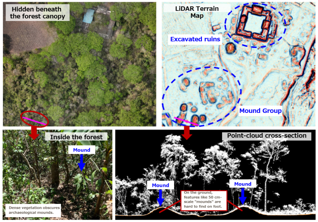
Candidate features identified by combining aerial photography, field photographs, topographic maps, and point cloud cross-sections
Results
Microtopography beneath the forest, visualized at roughly 32 times the ground point density of the earlier survey
The pilot survey acquired a ground point density of 93.2 points/m², approximately 32 times the 2.91 points/m² of the 2013 survey. All-return point density, covering ground surface and vegetation together, was 20,869 points/m²—approximately 948 times the 22 points/m² of that earlier survey.
| Method | 2013 survey | This pilot survey | Ratio |
|---|---|---|---|
| Ground point density | 2.91 points/m² | 93.2 points/m² | approx. 32x |
| All-return point density | 22 points/m² | 20,869 points/m² | approx. 948x |
What the data delivered
- Fine undulations: Ground-surface change on the order of 50 cm beneath dense vegetation, made visible.
- Extraction of candidate features: Numerous mound-like landforms identified, indicating the possibility of past human modification.
- Comparison with known archaeological features: The extracted landforms and known excavated features can now be compared within a single dataset.
- A record of the cultural landscape: Alongside the terrain, forest structure at the time of the survey (canopy, stems, and understory vegetation) preserved in three dimensions.
Notes on interpreting the results
The mound-like landforms identified in the data are considered candidate archaeological features. Establishing them as archaeological features requires further verification by researchers: ground survey, test excavation, and comparison with existing records. The 50 cm figure is not a measure of accuracy or a ground resolution; it indicates the scale of terrain change this data could visualize.
Conclusion
Copán presented a specific requirement: to capture fine terrain beneath the forest at a density that allows comparison with known archaeological features. We met it by acquiring ground points with high-density airborne laser scanning, and by recording vegetation and ground surface in a single 3D dataset.
The survey achieved a ground point density approximately 32 times that of earlier work, visualizing undulations on the order of 50 cm and multiple mound-like landforms. This can serve as an information base not only for finding candidate features, but for understanding their form and relationship to the surrounding environment, and for deciding the priority of field survey.
What is new in this case
- Showed the potential of high-density ground points for more detailed comparison and interpretation of microtopography beneath the forest
- Recorded terrain and forest structure simultaneously, creating an integrated dataset of the heritage site and its natural environment
- Confirmed the technical basis for scaling from a small pilot survey to a wide-area survey of approximately 2,500 hectares
Next steps
- Ground survey and archaeological verification of candidate locations
- Wide-area survey of approximately 2,500 hectares across the Copán Valley using an industrial unmanned helicopter
- Integrated analysis with forest structure and biodiversity assessment
- Use in education, museum exhibitions, digital archiving, and virtual tourism
 Contact us
