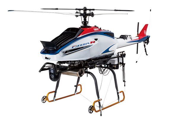
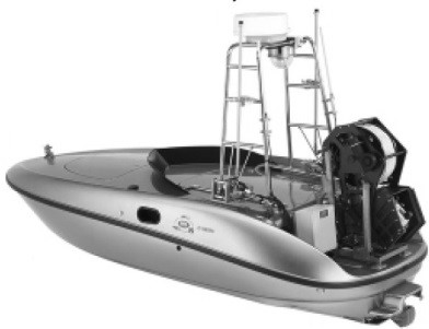
Industrial Drone with Maximum Payload 35kg,Maximum Altitude 2,800m, Cruising Range of 90km Yamaha Motor: FAZER R G2 Automated Navigation Unmanned Helicopter Showcased at the October "Japan International Aerospace Exhibition 2016"
October 11, 2016
IWATA, October 11, 2016—Yamaha Motor Co., Ltd. (Tokyo: 7272) announced today that it has developed a new automated navigation unmanned aircraft (commonly known as "drones"), the FAZER R G2, a high-end model for the industrial sector. Rental and service provision of these drones for industrial purposes such as measurement, surveying, surveillance, photography, and transport will begin from April 2017.
The FAZER R G2 is an industrial drone for automated flight to uninhabited areas out of visual range, and delivers excellent performance through its maximum payload of 35kg, maximum altitude of 2,800m, and cruising range of 90km.
The FAZER R G2 is also being exhibited at the Japan International Aerospace Exhibition 2016 being held at Tokyo Big Sightfrom Wed. October 12 to Sat. 15.
Yamaha Motor has been involved in a wide range of measurement, surveying, surveillance, and photography operations since 2006 using the RMAX G1 automated navigation industrial-use unmanned helicopter. Takeoff and landing of automated navigation unmanned helicopters is conducted by an operator using a remote control. After takeoff, the aircraft can fly to areas including those out of visual range using a pre-programed route, leading to its use in a broad range of applications - such as volcanic surveying and radiation measurement - for which it has been evaluated very highly. The new FAZER R G2 has been developed building on the law revision in 2014 (takeoff weight limit increased from 100kg to 150kg), offering significant increases in payload capacity, operating altitude, and flight time over the previous model.
Specifically, this new model is based on the FAZER R launched in 2016, adding new features such as automated flight control systems, a 12-liter fuel tank, and attachments for mounting photography and measurement devices. By combining these new features while retaining the control systems proven in the RMAX G1, the field of operation has been expanded. Moreover, the permitted payload being increased from 10kg to 35kg and the operating altitude being increased from 1,000m to 2,800m enables surveying of previously-unreachable high-altitude volcanic mountains such as Mount Asama, Mount Tokachi, Mount Kusatsu-Shirane, and Mount Aso.
Finally, through the fitting of a satellite-capable transmitter-receiver, the cruising range has been expanded to 90km (12-liter fuel), compared to 3km for the previous model, the RMAX G1.
| Model | Rental and Service Provision Begins | Applicable Customers/Region |
|---|---|---|
| FAZER R G2 | April 2017 | Legally-incorporated Bodies/Japan |
Market Background and Product Positioning
Called the "aerial industrial revolution" by some, expectations have been increasing in recent years for the creation of new industries and services by drones, and legal frameworks regarding unmanned aircraft are being prepared around the world. This product is an industrial drone corresponding to Flight Level 3: Automated flight to uninhabited areas out of visual range *1 of the Japanese Cabinet Office's "Utilization and Technological Development Roadmap of Small Unmanned Aircraft." The usage of a gasoline engine as motive power enables achieving specifications favorable to use in uninhabited areas out of visual range, such as maximum payload of 35kg, maximum altitude of 2,800m, and cruising range of 90km.
*1 In the "Utilization and Technological Development Roadmap of Small Unmanned Aircraft" produced by the "Government-Private Sector Working Party on Environmental Preparation for Small Unmanned Aircraft," drone flight levels are specified as the following; Level 1: Controlled flight within visual range, Level 2: Automated flight within visual range, Level 3: Automated flight to uninhabited areas out of visual range, and Level 4: Automated flight to inhabited areas out of visual range.
Business Expansion Plans
Rental and service provision of these drones to research institutions and other legally-incorporated bodies undertaking work such as measurement, surveying, surveillance, and video recording will begin from 2017.
| Item | Specification Value | |||
| Dimensions/Weight | Overall Length x Width x Height | 3,665mm x 734mm x 1,226mm | ||
| Main Rotor Diameter | 3,115mm | |||
| Tail Rotor Diameter | 550mm | |||
| Total Takeoff Weight | 81kg | |||
| Engine | Engine Type/Cylinder Arrangement | Liquid-cooled, 4-stroke, OHV, 2-valve, horizontally-opposed 2-cylinder engine |
||
| Total Displacement/Bore x Stroke | 390cm3/66.0mm x 57.0mm | |||
| Maximum Output | 20.6kW at 6,000r/min | |||
| Fuel Type/Fuel Tank Capacity | Regular gasoline/12ℓ | |||
| Performance etc. | Operating Altitude (*1) | 2,800m | ||
| Payload (*1) | 35kg/20°C, 1 atmosphere | |||
| Maximum Speed (forward airspeed) | 20m/s | |||
| Rate of Climb, Rate of Descent | 3m/s, 3m/s | |||
| Operating Range (*2) | 30km | |||
| Cruising Range | 90km | |||
| Cruising Time | 100 minutes | |||
*1 Operating altitude and payload are estimated with the fuel load at half (6ℓ).
*2 Operating Range and cruising range are based on the use of a satellite transmitter-receiver.
Reference
Yamaha Motor has been advancing research and development of Unmanned Vehicles (UMVs) based on compact vehicles such as industrial-use unmanned helicopters, ATVs, golf cars, and marine vehicles etc.
□Unmanned Aerial Vehicle(UAV)
Automated navigation aircraft were put to practical use in the volcanic surveying of Mount Usu in 2000 through, based on the RMAX industrial-use unmanned helicopter, mounting GPS units on both the helicopter itself and operating base station. This system allowed flight both on a route set in advance using a PC, or by positional control by the operator in units of tens of centimeters even when out of visual range. Through watching the video from the helicopter's on-board camera on the base station monitor, the operator was able to pilot the helicopter as if they were themselves on board, and approach the crater mouth itself (which would not be possible in a manned aircraft due to the risk), taking still and video images which were instantly beamed back, contributing to the survey activities. The helicopter was delivered to the Ministry of Land, Infrastructure, Transport and Tourism Hokkaido Regional Development Bureau, and has also been used in river surveys, disaster site surveys, etc.
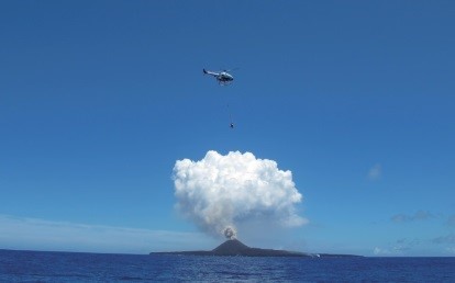
The know-how developed in this initiative was subsequently put to use in coastline measurement, volcanic surveying, and surveillance, and the RMAX G1 automated navigation industrial-use unmanned helicopter was developed in 2006. In the ten years since, it has been used for work in places where people cannot enter, such as volcanic activity surveys. It has recently been at work at Nishinoshima, which resumed eruptions in November 2013 following a 39-year hiatus, photographing lava flows and birds living on the island and collecting samples of volcanic stone. The newly-announced FAZER R G2 further enhances the basic functionality of the RMAX G1.

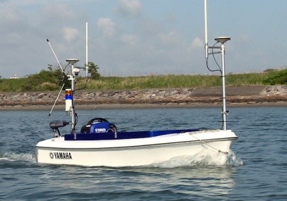
□Unmanned Marine Vehicle(UMV)
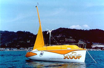
Around the same time as the observation of Mount Usu, Yamaha Motor was also implementing the practical use of UMVs which travel on water. Based on an order from the Japan Science and Technology Agency, YMC designed and built the Kan-chan unmanned oceanic and atmospheric survey vessel, which was launched in March 2000. Surveying of aerosols in the oceanic atmosphere had until that time been mainly carried out on isolated islands or a limited number of ships and surveying buoys, which meant that almost no data had been collected on the open sea, particularly the North Pacific Ocean. The solution to this problem was Kan-chan, which enabled data collection on the open sea over a wide range and long period, and was expected to contribute to academic research such as on global warming.
In 2004, the second UMV model, the UMV-H, was announced. Designed for surveillance use, this high-speed craft of 4.44m in length uses a water jet propulsion system to achieve a maximum speed of 40 knots. In terms of navigation, sailing past set points is possible by mapping a route. Development took approximately one year, and included technologies fostered in unmanned helicopters, such as attitude control of the automated unit, navigation devices, gyro and acceleration sensors, and the azimuthal system sensors. The actuators also feature the application of servo functions developed in YMC's industrial robots business. In this way, the UMV-H features many uniquely Yamaha technologies.
Such marine UMVs have recently been applied to dam silt level measurement in Japan, improving the efficiency of surveying the floors of bodies of water through their sonar etc. and contributing to dam maintenance. Among these, the BREEZE10 model announced in 2016 utilizes U.S.-made sonar, the most common in dam surveying work. Also featuring a compact design which can be transported in minivans, rental has begun to legally-incorporated bodies undertaking dam surveying work.
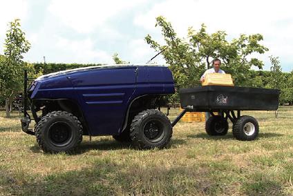
□Unmanned Ground Vehicle(UGV)
Yamaha Motor is developing UGVs, which apply the basic functionality of ATVs (all-terrain vehicles), as a first step to resolving issues in agriculture. International competition is particularly fierce in fruit cultivation, causing the maintenance of quality and increasing work efficiency to be major issues. YMC's development includes building systems which contribute to labor saving in situations within orchards requiring movement, such as transport, chemical spraying, and fertilizer application.
There are currently no examples of practical implementation of autonomous operation of unmanned vehicles in complex rough terrain such as found in orchards, but YMC is continuing research on practical implementation using relatively low-cost and simple cameras and two-dimensional laser range finders (LRF). Various trials have begun using a research and development vehicle whose cameras and LRF capture the necessary information for a system which travels while avoiding obstacles. Five patents have currently been applied for, including technology to travel while using LRF to count the number of trees.
The research and development platform is currently a Yamaha Motor ATV, but as YMC also has a variety of base vehicles other than ATVs, YMC is aiming to build unmanned vehicle systems to suit various objectives utilizing those other vehicles.
Top